Sydney to Broken Bay (Pittwater)
7/5/16 –
12/5/16
( Blog readers please note - by left clicking on photos you will see them full size and a photo gallery below. The same applies for previous blog posts..see blog archives below.)
Having left Brian and Maree on Urchin, we retired to our on-board
accommodation in the expectation of a sparkling morning for leaving Sydney
Harbor rounding North Head, and, with the forecast being fine for the morning
before an afternoon nor-aster, enjoying a “tourist sail” up Sydney’s northern
beaches, to compliment the voyage we had enjoyed immensely up the southern
beaches from Port Hacking. We thought that in the morning, with an alarm set,
we would see ferries busying their way across the Heads, in the golden light of
dawn. How wrong we were.
 |
| Dawn farewell to Urchin |
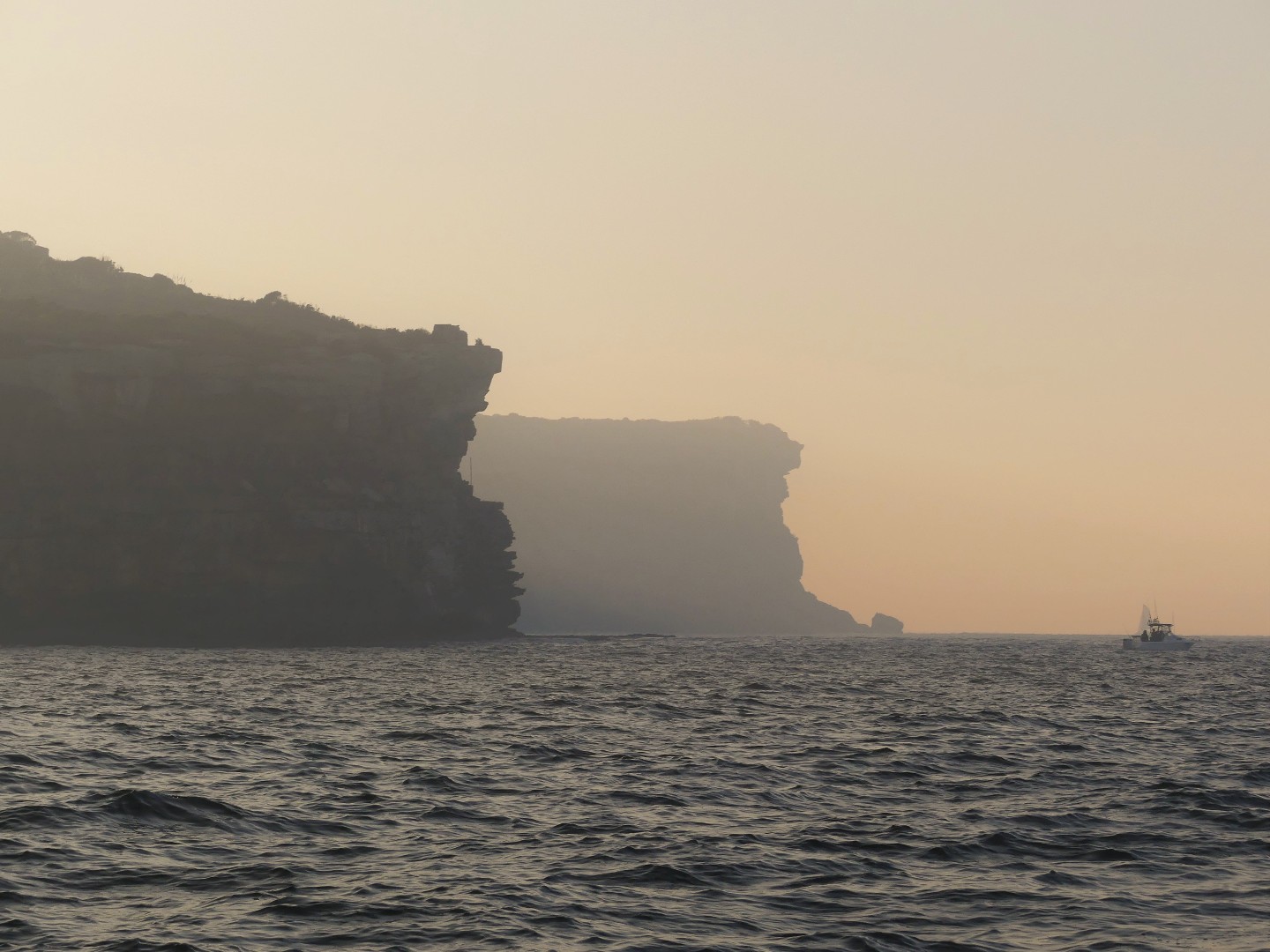
Peering out the cockpit at first light was to
look upon the world as through one was seeing it through one of Grandma’s
frosted sherry glasses. Spring Cove was
obscured by a bronze haze with visibility down to a hundred metres or so. It
was a smoky pea-souper, with the hint of burnt eucalypt in the air. The day
before, environmental authorities had advised that up to 40 “fuel reduction”
fires were to be lit in the Blue Mountains, but with the cool of the evening,
the smoky air had slithered down from the hills and over the city like a carpet
snake, oozing down the valley of the Parramatta, to where it now squatted, over
Sydney. It was a classic temperature inversion, and it might take hours to
clear. Yuk.
 |
| Hazy vista beyond North Head |
Hoping for better out to sea and to the
north, we hoisted anchor and made our way out of the harbour and around North
Head. Abeam of Manly Beach, we knew it was there because of our chart plotter,
but, not a glimpse of the land could we see. Luckily we could set a course
parallel to the coast and monitor our progress on our instrumentation. The
great northern beaches including Freshwater, Curl Curl, Dee Why, Long Reef and
Collaroy passed by unseen although off Long Reef, we were able to see an
airborne view of this potential hazard courtesy of a function on our chart
plotter. The C-Map program has thousands of aerial views of Australia’s
coastline and its islands in its system, and to access these we merely have to
click on one of the camera icons and the view of that spot from aloft is there
to be enjoyed. The practical value of this function is enormous, particularly
when approaching an unfamiliar coastline. At night on watch, we often take
ourselves on a “tour” of relevant sections of the coast, sometimes to prepare
for what is to come, and sometimes, purely for entertainment. Now, off Long
Reef, a click of the cursor has us seeing from above, on a clear day, that
which lay unseen, only a mile away.
 |
| Image of Long Reef on the Chart Plotter |
Off Narrabeen Beach, the air at last cleared
and we emerged into a bright and sunny day with a cloud of boot-polish brown
obscuring the horizon and disappearing astern. The evening news that night made
much of the blanket of “smog” that had frustrated tourists viewing the Sydney
Harbor Bridge and the Opera House, and had been a genuine irritant to those
managing chest conditions. With Bungan
Head ahead, Warriewood, Mona Vale and Bungan Head beaches were passed before we
reached it and, then, we made for Newport, Bilgola, Avalon, Whale, and Palm
Beaches, before the exclusive northern suburbs gave way to the prominent
buttress that is Barrenjoey Head.
 |
| There is a coastline here! |
 |
| Coastal beach shacks near Palm beach |
Broken Bay opens up once Barrenjoey Head is
cleared, and it is the gateway to a remarkable set of waterways that are
diverse, divine and impossible to ignore. Immediately to port once Barrenjoey
is rounded, is the famous marine playground of Pittwater, a five mile finger of
boat-mania, with a thicket of masts, like a Sumatran bamboo forest. We had been into Pittwater in 2010 and at the
Prince Alfred Yacht Club, and the Royal Motor Boat Club, we had ooooh and
aaah’ed enough for twenty voyages (see our blog – calista10.blogspot.com, posts
May and November). Whereas we cruise the coast on a budget, it was apparent
that in Pittwater money rules the waves. Having stocked our larder, we had no
need to divert to the south, and besides, we could ill afford to make an error
and hit anything in Pittwater.
 |
| Barrenjoey Head |
On the northern side of Broken Bay, Lion
Island, crouches like an Egyptian hieroglyph, and watches over the entrance to
Brisbane Water. Here the marked channel leads to the broad bay that is the
actual Brisbane Water, ending on the shores of Gosford, miles away.
By heading west and into Broken Bay, the wide
entrance to the Hawkesbury River opens to the north-west where entrance for
cruising yachts is soon thwarted by the Sydney-Newcastle railway bridge,
although power craft make the waters above the bridge their own and they are
able to ply the waters of this system for almost 70nm, reaching as far as
Sydney’s western suburb of Windsor. This is a watery playground in its own
right, complete with marinas, designated jetties and courtesy moorings: and
enough towns, shops, pubs tourist attractions and waterside facilities to last
a lifetime; without ever feeling an ocean swell.
As we burbled our way into broken Bay we
eschewed all of these, heading for the unremarkably named Cowan Creek, which
fingers its way deep into New South Wales’ second oldest reserve, the
Ku-Ring-Gai Chase National park. Since briefly entering this waterway in 2010,
we had Cowan Creek listed as one of our “must see” destinations this time
around. Cowan Creek bears many similarities to its famous neighbour to the
south, Sydney Harbour, and is a drowned river valley, of recent geologic
standing, just like Sydney. Unlike Sydney, whilst Cowan Creek and its
offshoots, Coal and Candle, and Smith Creeks, are immensely popular waterways
that can be navigated for miles, the uplands and spurs between, being part of
the Ku-Ring-Gai Chase National Park, are natural bushland and forest, and not
part of suburbia. These waterways carry the name ‘creek’, but their dimensions,
and everything else about them make them unlike any other creek we have ever
seen. Like South West Arm in Port Hacking, but on a grander scale, once you
round the entrance into Cowan Creek, the frenetic world just over the horizon
is left behind, and the surrounds are much as they have been for an eternity.
 |
| View back to Barrenjoey from Fishermans Beach |
In response to the popularity of Cowan Creek
and its offshoots, National Park authorities have installed courtesy moorings
in 14 of the bays and coves, so that visiting there can be an easy steam between
moorings of preference, according to the wind and fancy. The first bays off
Cowan Creek, the joint America Bay and Refuge Bay inlet lie before the National
Park zone, and because of its proximity to Pittwater, its all-round shelter,
and that it has a plethora of moorings as thick as hundreds and thousands on a
tot’s cup-cake, it is impossibly popular. This was our sole Cowan Creek
visitation in 2010, and we must have been there in mid-week, for now it was
crammed with boats and we quickly voted to move on upstream, where to be on a
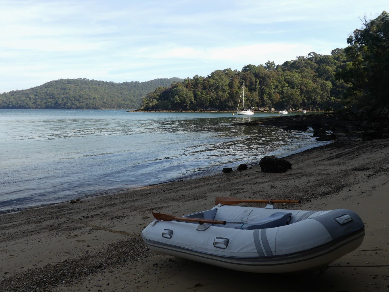
boat was less like being at the Royal Show. We selected Fisherman’s Beach on the northern
shore of the creek for lunch and later shifted to the lee of Little Shark Rock
Point, where we felt we could gain excellent shelter from a predicted
northerly, and take the chance to go ashore and explore.
 |
| Little Shark Rock Point |
Beaches are few in this region owing to its
steep-sided topography, but at this point, a small patch of sand emerged,
periodically, at low tide, enough for us to haul up our duck while ashore. From
the beach, a challenging clamber across jagged and oyster clad rocks along the
shoreline was possible, but going far was out of the question. Taking what
appeared to be a path of sorts heading up and away from the cove, soon had us
in thickets of scrub under towering eucalypts, where a machete might have been
handy and every gap in the foliage had golden orb spiders dangling malevolently
from intricate webs. Not seeing one of these webs and having it tangle on your
face alongside a cranky arachnid would be enough to bring on a phobia. To head
deeper into the forest was out of the question and we returned, defeated, to
the beach. It was not hard to understand why the first settlers of Sydney were
thwarted in their attempts to blaze a trail across the Blue Mountains, and it
was not until 1813 that Blaxland, Lawson and Wentworth finally got there by
following the ridges and not the valleys, into the unknown.
 |
| Successful landing on low tide at Little Shark Rock Point |
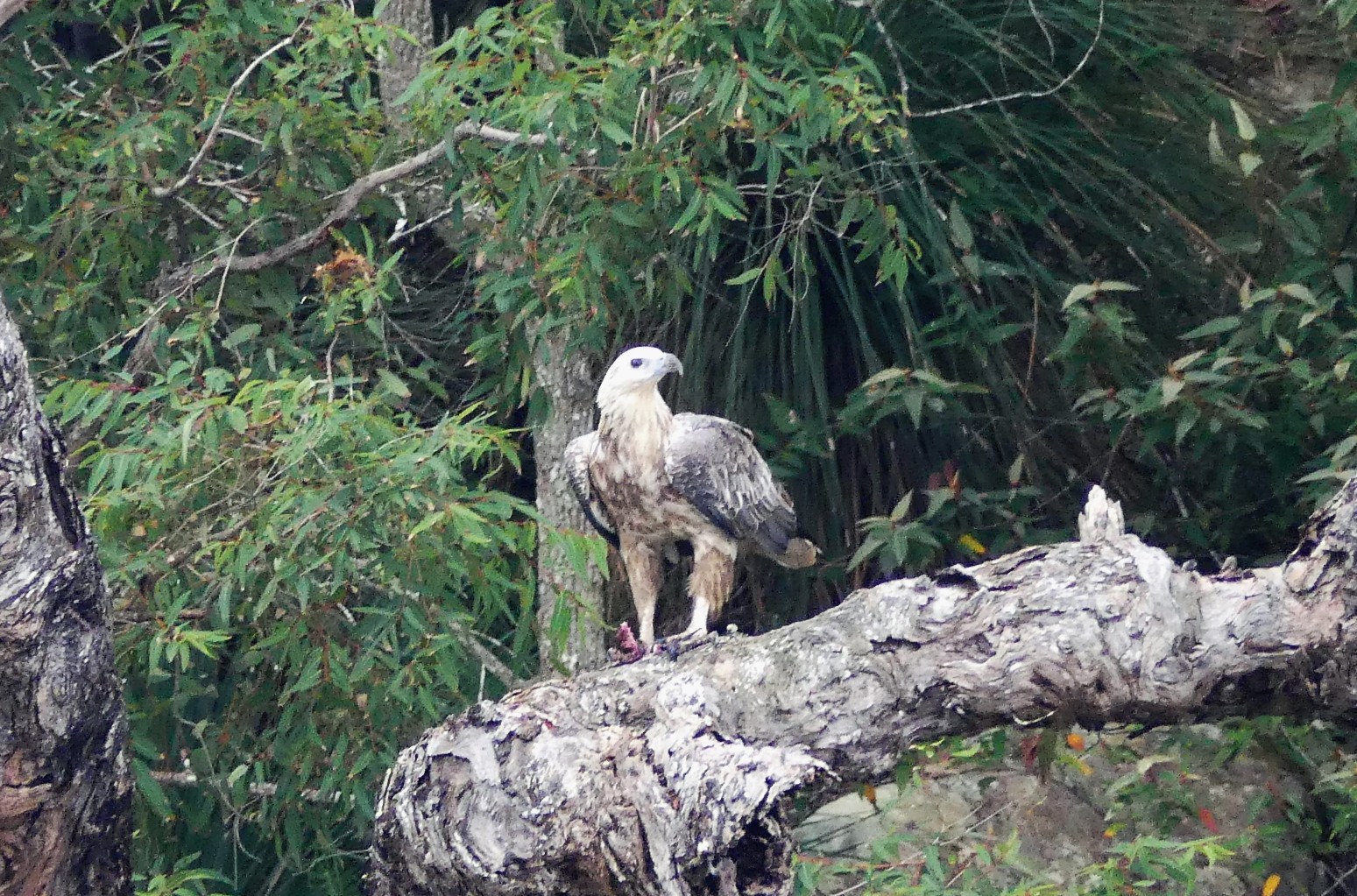
Back on the beach we noted that our
footprints of only minutes earlier had been crossed by a creature of sorts, and
given its drag and claw markings, we suspected that our progress up the beach
had been monitored as it were, and sure enough, not far away there it was, a
black Goanna, lying as still as a stick with flickering tongue and bead-like
eyes. It eyed us curiously and we left it in peace, content in the autumnal
sun. Aloft, a juvenile Sea Eagle wheeled effortlessly before alighting on a
tree on the point, eyeing speculatively the shoals of fry flitting in the cove,
oblivious to the fine line that they were drawing between swimmer and dinner.
It was hard to comprehend that earlier the same day we were in suburban Manly.
 |
Wonderful wildlife
|
Given the beauty of the forest all about, we
yearned to explore a walking trail in the area, but realised that many of the
trails into the Chase from suburbs to the south made their way along the ridges
far above but did not wend their way down as far as the water. Given our
experience, we could understand why. Weekends attract hordes of craft into these
waterways; gleaming motor cruisers, sleek yachts, fishing runabouts sprouting
rods like antlers, houseboats like eskies afloat, and the odd jet ski, as
irritating as a blowfly around a carved joint. For those on a mooring the
palatial motor cruisers - we are like many sailors and dub them “stink boats” -
are the worst, growling their way past like a highway b-double, furrowing the
water like a mallee plough and leaving us to dance and heave in their wake. We
were happy to see the end of the weekend, and we suspect that the sea eagles
were happy too.
The return of tranquillity saw us embark on
our own exploration of the waterways. Out at sea, there were strong wind
warnings for nearby waters, but here in Cowan Creek the winds passed harmlessly
overhead with only the scudding clouds giving hint to the difference between
the outside world and the peace for us deep in the forest. There are three
marinas in these waterways, Akuna Bay on Coal and Candle Creek, Cottage Point
where this creek meets Cowan Creek, and Bobbin Head, located as far down Cowan
Creek as it is possible for boats to go. In between, yellow courtesy moorings
strategically dot the waters, and we opted to see how much of this remarkable
system of bays and inlets we could take in whilst we were there.
 |
| Cottage Point and all the boats moored at the Royal Motor Yacht Club |

Many years ago we sashayed through Sydney on
holidays and apart from traversing the Bridge, checking out the Opera House and
catching the Manly ferry, we took a self- guided drive up into Ku-Ring-Gai Chase
National Park, out of innocent curiosity and our clear preference for
wilderness over suburbia. Entering the Park, the road took us down into a
valley where to our utter astonishment we came upon a marina complete with svelte cruisers, an up-market café and a
multi-layered storage shed for runabouts, all snuggling into a cove deep in the
bush. It was hard to comprehend that here, miles from anywhere, was an offshoot
of the sea complete with tides, fish, and water that was salt to the taste. To
us this was boating for the rich and famous, aeons away from the tinny we had
at home, and a place that we were certain, we would never enter from out at
sea. This marina was Akuna Bay, and now, although we were neither rich nor
famous, we planned to make our way down Coal and Candle Creek to Akuna Bay, in Calista, just because we could.
 |
| Calista (centre )in the crowded Akuna Bay Marina |
On approach this time to Akuna Bay Marina,
although seeming as delicious as our memories told us, we were seeing the facility
through different eyes, via those in on board a cruising yacht and not as
visitors by road. What we saw this time, in spite of the welcoming entreaties
of management over the phone, was a cramped marina where the bow-thrusters
often seen on motor cruisers (this is a small propeller inserted into a
horizontal tunnel below the waterline in the bow, giving “push” to port or
starboard when docking) would be invaluable, but for us to get into a visiting
“pen” deep in Row B would require careful piloting and docking by our crew. Not
quite close your eyes and breathe in, but close. Ashore, and with a stabilising
cappuccino under our belts, in spite of ticking the “getting there” box, Akuna
Bay was just not a place where we wanted to stay. Give us a forested bay over
the glitz, the gold shoes and canapés any day. Yes, our revisit to Akuna Bay
would be a brief one, and now came the hard part, getting back out of the
marina in a boat that was reluctant to reverse in the direction that we
desired. We felt like a porcupine trying to back out of a burrow.
On our way to Akuna Bay, we had noted, off
Yeoman’s Bay, a further offshoot called Castle Lagoon that was cosy and as
close to idyllic as any place one could imagine. Yes, there were two other
boats in this secluded spot, but we could easily understand why this haven was
a local favourite. A hurricane could rage hereabouts and one could lay in
tranquillity in Castle Lagoon. We noted that although the rules for moorings
state that only 24hour stays are permitted, in Castle lagoon, the other boats
there made rules of their own, probably knowing that intervention by National
Parks officials was less than likely. Yes, Castle Lagoon lived up to its billing and
for an extra treat we had a cove – side sunset that held us in the cockpit
until the last rays receded in the west. It was spectacular.
 |
| Stunning sunset at Castle Lagoon |
In the new day we resolved to follow Cowan
Creek as far as we could go, as far as the Bobbin Head Marina. Close by was the
Cottage Point Marina with a lower-key appearance compared with Akuna Bay, and
with a fleet of boats tethered to Marina moorings bobbing in the stream out
from the jetty. Landing here did not grip our imagination, so we continued,
upstream, on our way. Along the way we
spied numerous mooring locations of great beauty, but we thought it time that
we got off the boat seeking a closer look at the local environment. Many
cruisers would be happy to pick up a mooring and spend the day relaxing,
fishing or imbibing it would seem, but we weary of just looking at places; we
want to experience them too.
 |
| One of the many mooring areas enroute to Bobbin Head |
On arrival at Bobbin Head, although there were far
too many expensive motor cruisers to count, there was a distinctly different
feel to the place that for some reason we warmed to. For one, just across the
bridge over Cockle Creek, at the National Park Information Centre, we discovered
that a loop walking track originating at Bobbin Head was literally waiting for
us to don our walkers and head off into the wilderness. Great!
The Bobbin Head – Sphinx Memorial – Bobbin
Head track of about 12km was just the ticket, offering a fascinating shoreline
tramp amongst the mangroves, followed by a climb through the forest to the
Sphinx, before a ridge-top return to Bobbin Head where elevated views of the
Park were a panoramic delight. The Sphinx is a post - World War One memorial, a
scaled down version of Egypt’s famous monument, carved from stone by an
ex-digger who in spite of lungs that had been scarred by gassing on the Western
Front, completed this remarkable sculpture in the 1920’s. The Sphinx was truly
a noble memorial to this awful time in our history, and seeing it was well
worth the effort that it took to get there.
 |
| Wonderful forest walks |
Back at Bobbin Head, our original intention
was to head out to one of the anchorages we had spotted on our way down Cowan
Creek, but the views of the waterways on our bushwalk, lined with mangroves and
sandstone cliffs, had been so enticing that we resolved to stay another night
and via our inflatable kayaks, to explore the area more fully. There were other
benefits too, including the opportunity to launder both some clothes and the
crew, and to take a longer look at some of the fine vessels that called Bobbin
Creek home. On one of the fingers we spotted a cruising yacht of exquisite
beauty, a Cabo Rico 38’ called Resolution.
With her sleek lines, classy timberwork and immaculate presentation she was
as beautiful a yacht as we had seen. There were many motor cruisers at Bobbin
Head that would have been far more expensive to purchase, but for sheer class,
and appeal to the crew of Calista,
Resolution had our attention.
 |
| Beautiful Cabo Rico 38 "Resolution" |
At Bobbin Head, the last outpost of Cowan
Creek, the creek divides into Cockle Creek and Cowan Creek proper. With kayaks
inflated, we resolved to follow both waterways as far as we could go. They were
superb. At once our Kayaks took us away from all trace of humanity, and we
glided over the ever diminishing creeks until they disappeared into streams
trickling over moss-clad boulders. Fish dashed hither and yon, including on one
sand bar a flathead as large as I have ever seen. Flooding tidal waters from a
distant sea slid amongst the mangrove shoots, drawing crabs from their holes,
whilst above, canyon walls of stone presented ochre coloured caverns, and all
about, ferns and sturdy forest giants lorded overhead. No motorised craft are
allowed on these waters and we were transported back to a landscape that has
been much like this for centuries. It was hard to comprehend that just beyond
the ridge-tops beetling above us, were the bustling suburbs of Sydney. This was
a fabulous experience, a genuine highlight of our time in Ku-Ring-Gai Chase
National Park.
 |
| Exploring Cockle Creek on our kayaks |

Our track out of Cowan Creek left but one
tributary of the main stream to explore. This is the mildly-termed Smith’s
Creek, which duplicates the grandeur of Cowan Creek, and is especially
attractive in the Twilight Inlet and Spirit Cove portions of the waterway.
Returning to Cowan Creek, with shadows lengthening, we thought to select a
northerly aspect cove and pick up a final mooring, but a closer inspection of our
chart showed that across the mouth of the Hawkesbury lay Little Patonga Beach,
and if we hastened, we could drop anchor there before darkness fell. From there
we could easily make our way seaward at first light on the 40 miles at sea to
Swansea, to cross the bar into Lake Macquarie. As we settled on our chain and
dinner was on the make, we reflected on our days in the Cowan Creek waterways.
We found them visually stunning and just perfect for those who love boating but
without the challenges of the open sea. For us, though, the open sea beckoned,
and in the dawn of the new day, we would set a course out of Broken Bay, turning
beyond Box Head to the North in weather that was forecast
to be near-perfect for the purpose.
 |
| Our extensive exploration of Cowan Creek recorded on our Chart Plotter! |